| roncli.com blog |
| roncli.com |
| blog |
| Profile |
 |
| roncli |
| Houston, Texas, United States |
| Labels |
| Coding |
| CTG Music |
| Editorials |
| Games |
| Miscellaneous |
| Music |
| Servers |
| Silliness |
| Software |
| Sports |
| Trax in Space Beta |
| Weather |
| Thursday, November 25, 2010 |
|
jQuery UI Scroll Menu 1.0 Posted: 11:52:00 PM 0 comments |
For the past couple of years, I've been getting more and more conscious about how many entries are starting to fill up the left side pane of the site. The months in particular are starting to become huge. What I wanted was a compact menu that you could scroll through, keeping the number of visible items down while allowing for any number of items to exist in the menu. Something like this: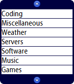 Last night, I started playing with DIVs, ULs, LIs, and jQuery UI to see if I could get to where I wanted to go. Well, after a couple of long coding sessions surrounding a bout with tryptophan, and after wrestling IE and Firefox into submission, I finally got what I wanted. Introducing jQuery-ui-ScrollMenu-1.0.js. Documentation can be found at the top of the file in the comments. It should be fairly straightforward, although instead of using CSS like I had wanted, I instead just went with setting CSS styles. I'm not 100% happy with how the code was put together, but the bottom line here is that it works, and it's pretty. Perhaps I'll go back and make it compliant with CSS (or maybe someone will do it for me!), but for now I'm going to release it as is. Labels: Coding, JavaScript, jQuery UI Scroll Menu, Screenshot |
| Saturday, September 13, 2008 |
|
Ike coming ashore right now Posted: 2:11:00 AM 0 comments |
|
2 AM NHC update is in, and Galveston is now in the eye of the storm. Conditions outside here in the Galleria area have gotten crazy. I'm honestly amazed I still have power and am online. Last I was outside about 20 minutes ago, it was popping, and the sky was lighting up some shades of green, as transformers around me went out. Category 2 is going to be what the storm landfalls as, 110 mph winds. Here's my latest images. ike20.jpg: Latest track. ike21.jpg: Radar image. ike22.jpg: Landfall. 75 mph winds in town now. Fires in Galveston. 6 feet of flooding in downtown Galveston. Fun. Labels: Galveston, Hurricane Ike, Life, Screenshot |
|
Midnight Ike images Posted: 12:20:00 AM 0 comments |
|
Well, NHC doesn't agree that it's straightening out... so it may miss Galveston to the east some. The beginning of the eye wall will start hitting Galveston within the hour. ike18.jpg: The track as of midnight, a bit off from the forecast from 2 hours ago. ike19.jpg: Radar. 'Nuff said. Labels: Hurricane Ike, Life, Screenshot |
| Friday, September 12, 2008 |
|
More Ike images Posted: 11:23:00 PM 0 comments |
|
Ike moves closer to shore, and actually took a jog to the north over the last 2 hours. This may spare Galveston from the worst of the hurricane. It is still the strongest of category 2 hurricanes at 110 miles per hour, and it's slowed down a bit. Landfall is now predicted to be just before sunrise. I actually got a chance to play some World of Warcraft, a much needed stress reliever for me. Power flashed off and on twice over the past three hours, but nothing too disruptive that I couldn't handle. The rain has started, although the winds haven't picked up too noticeably over the last few hours. I'm sure that's all about to change. Here are some more images. ike15.jpg: Ike's track and cloud cover. Note the track's been adjusted to the east somewhat. ike16.jpg: A radar shot out of Galveston, different than the one I posted previously. Scary stuff. ike17.jpg: A false color image of Ike... very, very impressive looking. We should be in for one helluva ride. Labels: Hurricane Ike, Life, Screenshot |
|
ISS view of Ike Posted: 4:44:00 PM 0 comments |
|
Just wanted to link to this spectacular image of Ike. Labels: Hurricane Ike, Life, Screenshot |
|
Ike closing in Posted: 4:34:00 PM 0 comments |
|
The 4 pm update is out. No real change, still aiming for Galveston, still 105 mph winds as a category 2 hurricane. Landfall seems as though it's going to be well past midnight, so the morning should bring the fury of the storm into Houston. Local radar suggests that the rain should be on its way soon. I just went outside a second ago, and the wind is picking up, though it's well short of tropical storm winds (39+ mph) at the moment. Some more Google Earth imagery for you to enjoy. ike11.jpg: The latest track for Hurricane Ike. The models are not showing up properly in Google Earth (they went back to models from a day ago), so they are excluded from this picture. But the models aren't important anyway, they are all tightly clustered around Galveston island. ike12.jpg: Color image of Ike. Looks somewhat more impressive than 3 hours ago, but still not nearly as impressive as that Gulf-filling monster that it was yesterday. ike13.jpg: Visible satellite. You can kind of see a huge eye forming in the middle of it all... if the overlay is accurate, this could mean that Ike is tracking somewhat north of what was expected, which, if that's true, may miss Galveston with the worst of the storm surge as a result. ike14.jpg: Radar image. Like I said, huge eye. Hmm. I *think* I just heard thunder. On with the show. Labels: Hurricane Ike, Life, Screenshot |
|
Ike still on track Posted: 1:50:00 PM 0 comments |
|
Overnight, NHC changed their forcast, and called for the hurricane to move somewhat east. It wasn't a major difference, only a few dozen miles if that. But, since the 10 am report, Ike has wobbled to the west a bit. This means there's still a high chance that the hurricane will track right over me, or to my left, both bad situations. The hurricane's max winds have increased to 105 mph, and some minor strengthening is anticipated before landfall, although they've been saying that for the last 48 hours and nothing happened. The hurricane looks a bit less organized than it did yesterday, but that's because the inner eye wall finally collapsed, and it might have a chance to build a new one in the next few hours. Nothing to report here yet, weather-wise. Things should start getting nasty in a few hours, though. Here's Ike's vitals: Category 2 hurricane, 105 mph 27.4 N, 93.1 W, moving WNW at 11 mph 957 mb pressure ike8.jpg: This image shows the wobble I referred to, as a fork off of that green line to the left. ike9.jpg: The Houston area image, now with hurricane Ike nearby. ike10.jpg: I don't know. It just doesn't have the impressive, "look, I'm kicking everyone's ass" look it did yesterday. Labels: Hurricane Ike, Life, Screenshot |
| Thursday, September 11, 2008 |
|
Ike 4 PM CDT images Posted: 4:39:00 PM 0 comments |
|
Courtesy of Google Earth! ike4.jpg: This shows the projected path (the multi-colored one with the hurricane icons on them), along with the leading models that say, we're pretty much screwed. ike5.jpg: Same data, but a detail of the Houston and surrounding area. Again, screwed. ike6.jpg: This image is almost unbelievable. Look at the size of this thing! It's a beast, bigger than Katrina was. It's still spreading rain across Cuba, Florida's just now getting left alone but still has some rogue bands affecting it, Yucatan's got some incoming bands, Louisiana, Alabama, and Mississippi will all feel something if this goes much more north, and of course Texas... yah, screwed. ike7.jpg: This piece of spaghetti is... well... spaghetti. That's why it's called the spaghetti models, a whole bunch of hurricane position forecasting programs, all on one map. No surprise, Houston is a tangled mess. I just noticed that between the 1 pm advisery and the 4 pm advisery that the storm is actually now back on a WNW track, which, unlike what I said in my last post, means that the storm's models are actually working as intended. But with my experience with Rita, nothing's certain yet. Be back at 7, after I've boarded up the windows. I'll be checking email all day, so if you have any questions, let me know. Labels: Hurricane Ike, Life, Screenshot |
| Thursday, May 03, 2007 |
|
Textboxes Galore Posted: 3:45:00 PM 0 comments |
 One of the things I am trying to do with OSMusic.Net's ASP.Net update is to make the user experience less of a chore and more fun. As I stated in a previous post, my goal was to load the presentation end with AJAX-like stuff, reserving JavaScript for mundane tasks. Apparently, textboxes are mundane. Microsoft provides no real way to manipulate textboxes using ASP.Net and its AJAX extensions. Thus, I had to use nothing but JavaScript to create the flashy addons that OSM's new textboxes are going to provide. OSM's current textboxes are just unmodified textareas, with the occasional JavaScript to limit the input to a certain size. In some cases, you'd get a half-page long description of how the special codes for formatting text worked. It wasn't very intuitive and didn't get a whole lot of use. So what I did was make a bunch of small 16x16 buttons, one for each possible tag, and two buttons specifically for the mass of smilies OSM uses. When a user clicks on a button that doesn't require anything, such as bold text, it adds a [b][/b] to the textbox, with the cursor in the middle so you can begin typing right away. If you have text highlighted, it puts the [b] in front and the [/b] at the end of the selection, so you don't have to place anything. You also get a reminder as to what the syntax is, so that if you want to type it in yourself, you can. The other tags are a bit different. Instead of immediately inserting anything, you have to provide some information. In the case of an image, you need the URL and the alignment - left, right, or none - it will have on the page. When you click the Insert button, you get a properly constructed [img] tag at the cursor. Colors are similar, you get sliders for red, green, and blue, and the syntax updates with the color you've selected, along with a preview of what the color actually looks like. There are two smiley pages. You just point your cursor in the box where you want to add it, click one of the two smiley page buttons, and select a smiley from the box below. No need to remember what the difference between :cheesy: and :laugh:, just select the one you want visually. It's all packed into a control and three JavaScript source files that manage all of the textboxes on a page. I'm quite happy with how it turned out, and look forward to actually being able to use it. There's not too many sites out there that allow for such easy adding of markup text. Labels: Coding, OSMusic.Net, Screenshot |
| Wednesday, June 14, 2006 |
|
Why does VB.Net hate me today? Posted: 7:36:00 PM 0 comments |
 Rather speaks for itself, doesn't it? Labels: Coding, Screenshot, VB.NET |
| Thursday, September 22, 2005 |
|
Lubbock Posted: 9:49:00 PM 0 comments |
|
After 16 1/2 hours of, well, lots of traffic and driving, we have arrived no worse for the journey at Jesse's place in Lubbock. I've been up since 8:30 am Wednesday, biked two miles, sawed four pieces of plywood-ish type stuff, operated power tools (the true sign of masculinity!), lifted many heavy things up and down stairs, and otherwise worked myself into complete exhaustion. I'm taking a nap. Rita, cat 4, 145 MPH, but it's tracking more north. NHC'll update in 15 minutes, I'll probably be asleep in 10. In the meantime, have at the current models. Sorry for the low res, I'm on a crappy monitor for the weekend. Labels: Hurricane Rita, Life, Screenshot |
|
Latest models Posted: 12:06:00 AM 0 comments |
|
These are the latest models as of 8 pm. I don't think the blue line is realistic. The NHC track from 10 pm is in the middle of the other three. Obviously, this is much worse than the last update, and would absolutely kill Houston. Speaking of kill, Rita is a killer with 175 MPH winds and a staggering pressure of 897 millibars. Labels: Hurricane Rita, Life, Screenshot |
| Wednesday, September 21, 2005 |
|
Hitting the Road Posted: 8:12:00 PM 0 comments |
|
As you no doubt can tell if you're a regular visitor, this ain't the regular site for my blog. The reason is we're hitting the road, and I wanted a place to be able to post information about me and Kathy while we are away. Yes, we're getting the hell away from Rita. This map should explain fairly sufficiently why. We're dealing with the third strongest storm (by barometric pressure, currently 898 millibars or 26.52 inches) in recorded history. I decided today to hit the road at midnight to minimize the time we're going to be in traffic in daylight. That said, we're probably going to hit quite a bit of it in the morning, I anticipate 12 hours to wherever we decide on going. I'll post that location before or as we leave. Overreacting? There's a saying that you cannot overreact to a category 5 hurricane. Oklahoma City may get some of the storm, probably as a tropical storm, so I'm aiming for Amarillo. We'll see, and I'll be sure to keep you updated along the way. Labels: Hurricane Rita, Life, Screenshot |
| Monday, September 05, 2005 |
|
More Katrina Posted: 4:12:00 PM 0 comments |
|
Now playing: DRAX - Zarathustra - (3:27) This before and after is Biloxi, MS. Of note is the building on the coast in the upper left which is entirely gone. The building in the lower left, however, had a somewhat better fate. It just blew across the street into a parking lot. Images are about 350 KB each. Before After Labels: Google Earth, Hurricane Katrina, Life, Screenshot |
| Sunday, September 04, 2005 |
|
Google Earth + NOAA + Katrina Posted: 5:47:00 PM 0 comments |
|
I did a before and after comparison of an image I was able to download from NOAA using Google Earth. In this shot, you will see the northern end of the city, along the shore of the lake there. The images are pretty huge, but the detail is worth it. Before After Coincidentally, my brother was in New Orleans Sunday morning, but thankfully he got out. He sure is a lot luckier than the tens of thousands who didn't. Labels: Google Earth, Hurricane Katrina, Life, Screenshot |
| Wednesday, July 27, 2005 |
|
Google Earth Take 3 Posted: 3:23:00 PM 0 comments |
|
Now playing: Gopher - 3: Meeting - The Gathering of Arms (6:39) I am enjoying this program far too much. My latest shot shows an approximation of the view I had from the Williams/TransCo Tower in the Galleria Area today. I was in for an interview with a company, and the office in which the interview was conducted had an amazing view of Houston to the south and west. Of course, I was too nervous to fully appreciate the view (see next post), so I had to come to Google Earth to check it out again. One of the interesting things about this program, and an indication of how far it still has to go, is the vertical perception of things is different. For instance, you may see the pools in the white complex in the middle of the page.... they were not present from my vantage point, obscured by the two stories of apartments around them. Also, the buildings behind where you see the label "Hidalgo St" are quite tall. But this is still pretty amazing software... Love the waterwall shot in the lower left. And I think what amazes me the most is that they found a time during daylight when the 610 & 59 interchange wasn't a parking lot... Labels: Google Earth, Screenshot, Software |
| Thursday, July 14, 2005 |
|
First National Radar Test Posted: 11:01:00 PM 0 comments |
|
Now playing: Namco - Sala de Masala 2000 (2:42) I completed my first national radar test based on NWS's data. Not quite where I would like it to be, as there is ground clutter and in the northwest there are two strange looking lines that are obviously not supposed to be there... apparently NWS doesn't filter them out automatically. You can see a comparable image at approximately the same time to see the differences. The good news is that the code obviously works. The bad news is that it took over 11 minutes to process all 136 radar sites in the continental US. NWS would have made two updates on each of those 136 radar sites in that time, not to mention that my radar data is now 11 minutes older than it was. A good percentage of that time is spent downloading the radar data from NWS to begin with. Considering I'm on a shared T3 and it took about 3 to 4 minutes to download less than 2 MB of data, that's relatively slow. But processing the files is taking the bulk of the time, and I may have to revisit the methods I use in order to get this to work faster. It could just be that I'm in debug mode, but I doubt that's going to help with the download speeds. Also, a lot of this is just computationally expensive. You figure there are 230 points I'm looking at for each degree around the radar - all 360 of them - for each of 136 radars. That's over 11 million pixels of data. Plus, since the map I'm displaying it on is a latitude/longitude map, I have to take into account that a nautical mile at 30 degrees of latitude is not the same as a nautical mile at 40 degrees of latitude. It gets complex, but I got a pretty good algorithm setup to do it. So in short, there's a long way to go yet before this is practical, but the ground work and understanding is there, which is usually 80% of the work. I'll probably post more on this in the future. Labels: Coding, NWS, Screenshot |
|
More Google Earth Posted: 9:53:00 PM 0 comments |
|
Now playing: Namco - Sala de Masala 2000 (2:42) I found a pretty neat Google Earth shot of Mt. St. Helens that I shared with my friend who lives near it... the detail is pretty spectacular. It doesn't have any of the 2004/2005 eruptions in it, but that's not entirely necessary either. Big file... 359KB, over 1000 pixels in both directions. Sorry, I have a big screen! Labels: Google Earth, Screenshot, Software |
| Tuesday, July 12, 2005 |
|
Speaking of Google Earth Posted: 7:36:00 PM 0 comments |
|
Now playing: roncli, The Nightstalker - Everytime (5:24) Here is a Google Earth shot of Track 1 from San Francisco Rush 2049. I couldn't highlight the actual track, but I do have the turns marked at least. It's wildly different than the actual game. For instance, Palace Dr. is not a 180 degree turn when it hits Richardson Ave., which eventually turns into Lombard. Unfortunately, the shot of the jump near Lombard Reservoir is awful, as the image has it in the shade. Be warned the shot is upwards of 650 KB. Labels: Google Earth, Screenshot, Software |
|
More NWS stuff Posted: 7:18:00 PM 0 comments |
|
Now playing: roncli, The Nightstalker - Everytime (5:24) While this is not related at all to the project I was working on the other day, I thought I'd present this interesting test I've been doing. Today I worked on parsing WSR-88D data. In short, it's data available for free on the NWS site that, when decoded, allows you to display radar images. I gotta say, this is pretty simple work when you know what you're doing. Check out this current image of Houston area radar. 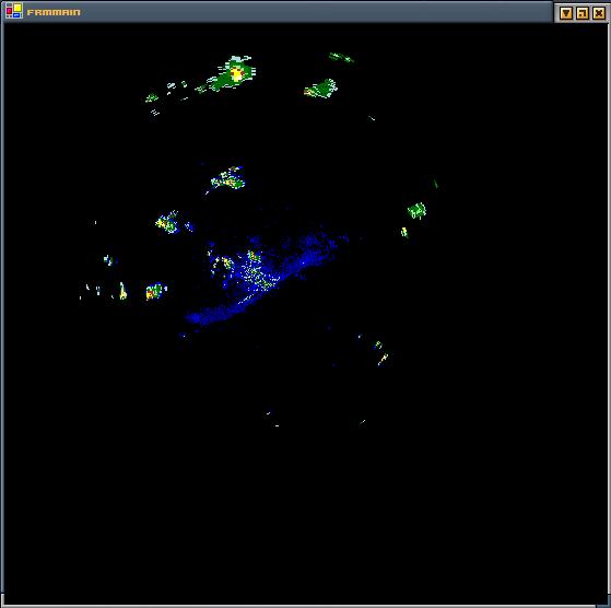 Although there are no borders, the ground clutter makes it easy to see Galveston and the bay. The northern end of the image reaches Dallas, while the western end extends beyond San Antonio and Austin. It should only be a matter of putting the pieces together in order to get not only radar that's more pretty, but something that'll pave the way into locally cached radar loops for insane time ranges that you just can't get on other sites, free or pay. The ultimate goal, of course, would be to import these images into Google Earth. They do have one radar service I saw, but it wasn't very good because it had the company's logo written all over the freakin' map. In any case, between this and the other NWS stuff I've worked on earlier this year, I almost have enough to put together for a desktop weather app. Might be interesting to see how far I can go with this. Labels: Coding, NWS, Screenshot |